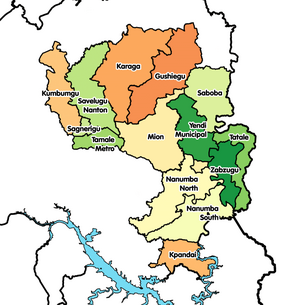
West Gonja Munisipal Desekyere
| Paaloŋ | Ghana |
|---|---|
| Located in the administrative territorial entity | Savannah Region |
| Coordinate location | 9°5′2″N 1°49′5″W |
| Shares border with | Bole Desekyere, North Gonja Desekyere, Sawla-Tuna-Kalba Desekyere, Central Gonja Desekyere |

West Gonja Munisipal e la a desekyere ayɔpõĩ na kaŋa naŋ be a Savaana Irigyiŋ poɔ, Ghana.[1][2][3] Ba da kuri o la ka o e desekyere Asambole 23 Disembare 1988 poɔ, ka ba da boɔlɔ o West Gonja Desekyere, te ta saŋa na Yidaandɔɔ John Agyekum Kufuor naŋ da wa wɛle a desekyere koɔmpare sɛŋ Ɔɔgere 2004 poɔ, na kuri Central Gonja Desekyere; kyɛ ka o kyɛlee na naŋ e West Gongya Desekyere. A puoriŋ, o da zɛge do la are munsipal desekyere voaraa 27 Gyɛnoɔre 2020 eŋɛ na leɛ West Gonja Munisipal Desekyere. A Munisipal bezie be la a Savaana irigyiŋ soga ane meŋ Damongo la e a o teŋkpoŋ.
O Noba Semmo
[maaleŋ | Maale eŋ yizie]A yi a 2010 noba semmo ane deri sɔrebo, a desekyere na baŋ taa la 41,180 noba, naŋ e 1.7% a Irigyiŋ zaa noba semmo. A laŋkpeɛreba poɔ, 80.2% la noba ba naŋ dɔge Ghana poɔ ane 60.3% noba naŋ tona toma, tona la lomboe ama eŋɛ zonnyɔge, Dagerekɔlkyɛ ane Daare toma lombori.
Kaa Kyɛ Meŋ
[maaleŋ | Maale eŋ yizie]- http://www.statoids.com/ygh.html
- https://web.archive.org/web/20051220143612/http://www.ghanadistricts.com/index.asp

