Kpandai Desekyere
Yelnyɔgeraa
Kpandai Desekyere
| Paaloŋ | Ghana |
|---|---|
| Located in the administrative territorial entity | Northern Region |
| Located in time zone | Greenwich Mean Time |
| Coordinate location | 8°29′0″N 0°1′0″W |
| Shares border with | East Gonja Munisipal Desekyere, Nanumba South Desekyere, Nkwanta North Desekyere, Nkwanta South Munisipal Desekyere, Krachi Nchumuru Desekyere |

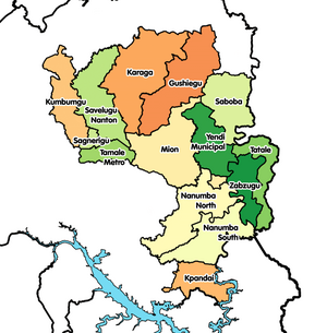
Kpandai Desekyere[1] e la a desekyere pie ne ayoɔbo na kaŋa naŋ be a Northern Irigyiŋ poɔ, Ghana.[2] O da daŋ paale la a East Gonja Desekyere kpoŋ na poɔ 1988 eŋɛ, te ta saŋa na yidaandɔɔ John Agyekum Kufuor naŋ da wa wɛle a desekyere eastern sɛŋ 29 Fɛboɔre 2008 na kuri Kpandai Desekyere.; kyɛ ka o kyɛlee na naŋ e East Gonja Munisipal Desekyere. A desekyere asɛmbole bezie be la a Northern Irigyiŋ[3] southern sɛŋ, a taa Kpandai ka o e o teŋkpoŋ.
Geogarapi
[maaleŋ | Maale eŋ yizie]A desekyere po la toribogiri ne East Gonja a o west sɛŋ, Nanumba South a o north sɛŋ, Nkwanta North ane Nkwanta South a o East ane Krachi West a o south sɛŋ.
Semmo
[maaleŋ | Maale eŋ yizie]Zipeɛre
[maaleŋ | Maale eŋ yizie]- http://www.statoids.com/ygh.html
- https://web.archive.org/web/20051220143612/http://www.ghanadistricts.com/index.asp
- http://www.ghanadistricts.com/About-District-Details.aspx?distID=128&distName=Kpandai/index.asp

