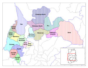
Jaman South Munisipal Desekyere
| Inception | 12 Nyɔgevennebare 2003 |
|---|---|
| Country | Ghana |
| Located in the administrative territorial entity | Bono Irigyin |
| Coordinate location | 7°35′13″N 2°47′17″W |

Jaman South Munisipal Desekyere e la a desekyere pie ne ayi na kaŋa naŋ be a Bono Irigyiŋ poɔ, Ghana. Naŋ da e Jaman Desekyere 10 maakye 1989 poɔ, a da wa kuri yi a Berekum-Jaman Desekyere koroo a Brong-Ahafo Irigyiŋ kpoŋ naŋ da bebe. A puoriŋ, o lombori kaŋa da wɛle la na kuri Jaman North Desekyere 12 Nyɔgevenne 2003 poɔ, kyɛ ka leɛ pore o kyɛlee na ka Jaman South Desekyere.[1] O da zɛge do la a puoriŋ are munisipal desekyere vuo araa Nyɔgevenne 2017 poɔ, ka ba leɛ pore o ka Jaman South Munisipal Desekyere. A munisipal bezie be la Bono irigyiŋ luo sɛŋ ane meŋ Japekrom la e a o teŋkpoŋ.
O ne ziiri ama la eŋ torebogiri;Berekum West Desekyere o kɔmpare sapare, Jaman North Desekyere a o saazu sɛŋ, Dormaa Munisipal a o kɔmpare ane La Côte d'lvoire a o luo poɔ. A munisipal teŋgane zaa gbuli na baŋ ta ŋa 700 km² (270sq mi) ane taa ŋa 130 tenne kponzie naŋ e tembilee semmo naŋ ba ta 400. O taa la teŋgane gbuli 1,500 km² ((580sq mi).
Tenne Yoe[maaleŋ | Maale eŋ yizie]
| No | Teŋɛ | Semmo | Semmo Yuoni |
|---|---|---|---|
| 1 | Adadiem | ||
| 2 | Adamasu-Adams | ||
| 3 | Adinkrakrom | ||
| 4 | Amanfoso | ||
| 5 | Asantekrom | ||
| 6 | Asuokor | ||
| 7 | Asiri | ||
| 8 | Atuna | ||
| 9 | Babianihaa | ||
| 10 | Basakrom | ||
| 11 | Bonakire | ||
| 12 | Buni | ||
| 13 | Mayera | ||
| 14 | Faago | ||
| 15 | Dodosuo | ||
| 16 | Dwenem | ||
| 17 | Faaman | ||
| 18 | Febi | ||
| 19 | Goka | ||
| 20 | Grobete | ||
| 21 | Gyinanko | ||
| 22 | Jamera | ||
| 23 | Jankufa | ||
| 24 | Japekrom | ||
| 25 | Jinini Kokoa | ||
| 26 | Kaabre | ||
| 27 | Kabile | ||
| 28 | Kokosua | ||
| 29 | Korase | ||
| 30 | Kwasibourkrom | ||
| 31 | Morle | ||
| 32 | Mpuasu | ||
| 33 | Gonasua | ||
| 34 | Nsonsomea | ||
| 35 | Nwamsua | ||
| 36 | Ponko | ||
| 37 | sambusi | ||
| 38 | Seketia | ||
| 39 | Suma Ahenkro | ||
| 40 | Yawtwenekrom | ||
| 41 | Zobo |

