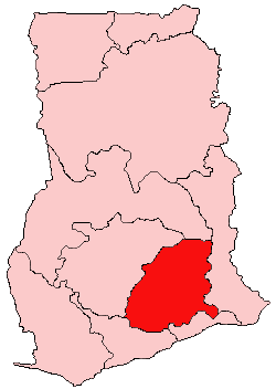
Akuapim South Desekyere
Yelnyɔgeraa
Akuapim South Desekyere
| Inception | 6 Fɛreboɔre 2012 |
|---|---|
| Paaloŋ | Ghana |
| Kapital/teŋkpoŋ | Aburi |
| Located in the administrative territorial entity | Eastern irigyin |
| Coordinate location | 5°48′0″N 0°14′0″W |
| Shares border with | West Akim Munisipal Desekyere, Suhum/Kraboa/Coaltar District, Akuapim North Munisipal Desekyere, Ayensuano Desekyere, Ga West Munisipal Asɛmbole |
| Follows | Nsawam-Adoagyire Munisipal Desekyere |
| Official website | http://aksma.gov.gh/ |

Akuapim South Desekyere e la a desekyere lezare ne pie ane ata na kaŋa naŋ be a Eastern Irigyiŋ poɔ, Ghana.[1][2][3][4] O da daŋ paale la a fɔrɔ Akuapim South Desekyere kpoŋ na poɔ 1988 eŋɛ, ba naŋ da kuri o a yi a Akuapim Desekyere kansil koroo poɔ; te ta saŋa na ba naŋ da wa zɛge o ka o do are munisipal desekyere asɛmbole vuo-araa na leɛ Akuapim South Munisipal Desekyere, ka Nsawam e o teŋkpoŋ. Ane a lɛ zaa 6 Fɛboɔre 2012 eŋɛ, a desekyere northeast sɛŋ da wɛle la na kuri Akuapim South Desekyere paala, ka Aburi e o teŋkpoŋ; kyɛ ka ba leɛ pore o kyɛlee na ka Nsawam Adoagyire Munisipal Desekyere, ka Nsawam e o teŋkpoŋ. A desekyere asɛmbole bezie be la a Eastern Irigyiŋ southeast sɛŋ, a taa Aburi ka o e o teŋkpoŋ.

