
Duoro kɔre:Ghana-Eastern.png
Boŋ zaa maaaloŋ kye
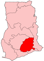
Ghana-Eastern.png (150 × 211 pixels, file size: 4 KB, MIME type: image/png)
| Description |
Map of Ghana showing Eastern region. |
||
| Bebiri | |||
| Yizie | Self-made, traced from public domain UN or CIA maps. | ||
| Creator | |||
| Sɔri sɔɔroo (Leɛtonaneŋ a daga ŋa) |
Provide attribution, please. See below. | ||
| Georeferencing | If inappropriate please set warp_status = skip to hide. | ||
| Other versions |
See Image:Ghana regions named.png for the numbered map of the regions.
|

I, the copyright holder of this work, hereby publish it under the following licenses:
This file is licensed under the Creative Commons Attribution-Share Alike 2.5 Generic, 2.0 Generic and 1.0 Generic license.
- Fo ba erɛ boŋ zaa:
- a pɔŋ – ka fo naŋ tɔgele, ŋmɛyaare ane toɔle a toma
- a laŋtaa – a sage a toma
- A yi a sobie ama yuoŋ:
- de manneneŋ – Aseŋ ka fo tere emmuo naŋ senne,a wanne sase-miri naŋ wullo o sobuo ane ka tɛgere kaŋ eɛ. Fo na baŋ eɛ lɛ yi lɛ na zaa fõõ naŋ boɔrɔ, kyɛ ka a ta e ŋa o soba la ko fo sori bee fo de tonne.
- tɔreko ayitaaloŋ mine – Ka fooŋ wa leɛ laŋtaa, leɛre kyɛ bee mɛ poɔ a yɛlɛ mineŋ see ka fo poŋ a fo boma na fo naŋ leɛre. a lɛ ne o zu bee sagedeebo laasene ka o e a papa meŋa.

|
Sore bebe la ka fo naŋ baŋ kaa la, poŋ a Gaŋpɛle na laŋtaa GNU sɛge bimbo sore terebo , Version 1.2 yelpaaba emmo leɛkaaboFree Software Foundation; kyɛ a zie waa ziyenaa, niŋe pageraa kyɛbe,sɛge, ane puori pageraa kyɛbe sɛge. Maale gama ayi naŋ wuli ka fo taa la sore na sɛgeGNU yɛlɛ sɛge biŋ sore. |
| A gbaŋe ŋa soobo be la Creative CommonsAttribution-share Alike 3.0 Unported license. | ||
| ||
| This licensing tag was added to this file as part of the GFDL licensing update. |
Fo naŋ baŋ iri la onaŋ fo na boɔrɔ.
Daga yɛlkori
Tɔ a bebiri/wagere a kaa a daga wagere na o naŋ sãã.
| Bebiri/Wɔgre | Bondemanna | Manna wulo | Tontona | Teɛroo | |
|---|---|---|---|---|---|
| pampana | 09:19, 27 Gyɔɔne 2005 | | 150 × 211 (4 KB) | Golbez | Map of Ghana showing Eastern region. Source: Made by User:Golbez. {{cc-by-sa-2.0}} Category:Maps of Ghana\ |
Daga tontone
The following 3 pages use this file:
Donɛɛ zaa daga tontone
Ana wikis mine ŋa maŋ tonna neŋ a daga ŋa:
- Era enna de.wikipedia.org
- Era enna en.wikipedia.org
- Akwatia (Ghana parliament constituency)
- Akim Swedru (Ghana parliament constituency)
- Atiwa (Ghana parliament constituency)
- Upper Manya (Ghana parliament constituency)
- Akropong (Ghana parliament constituency)
- Okere (Ghana parliament constituency)
- Aburi-Nsawam (Ghana parliament constituency)
- Ofoase-Ayirebi (Ghana parliament constituency)
- Asuogyaman (Ghana parliament constituency)
- Akim Oda (Ghana parliament constituency)
- Abirem (Ghana parliament constituency)
- Akim Abuakwa North (Ghana parliament constituency)
- Akim Abuakwa South (Ghana parliament constituency)
- Fanteakwa (Ghana parliament constituency)
- Kade (Ghana parliament constituency)
- Abetifi (Ghana parliament constituency)
- Afram Plains North (Ghana parliament constituency)
- Afram Plains South (Ghana parliament constituency)
- Mpraeso (Ghana parliament constituency)
- Nkawkaw (Ghana parliament constituency)
- Lower Manya (Ghana parliament constituency)
- New Juaben North (Ghana parliament constituency)
- New Juaben South
- Ayensuano (Ghana parliament constituency)
- Suhum (Ghana parliament constituency)
- Lower West Akim (Ghana parliament constituency)
- Upper West Akim
- Yilo Krobo (Ghana parliament constituency)
- Akwapim South (Ghana parliament constituency)
- Nsawam Adoagyiri (Ghana parliament constituency)
- Fanteakwa North (Ghana parliament constituency)
- Fanteakwa South (Ghana parliament constituency)
- Akuapem North (Ghana parliament constituency)
- Asene Akroso-Manso (Ghana parliament constituency)
- User:GerardM/Constituency of the Parliament of the Republic of Ghana
- Era enna gpe.wikipedia.org
- Abirem (Ghana parliament constituency)
- Akim Abuakwa North (Ghana parliament constituency)
- Akim Abuakwa South (Ghana parliament constituency)
- Akim Swedru (Ghana parliament constituency)
- Akwapim South (Ghana parliament constituency)
- Akwatia (Ghana parliament constituency)
- Asene Akroso-Manso (Ghana parliament constituency)
- Asuogyaman (Ghana parliament constituency)
- Ayensuano (Ghana parliament constituency)
- Fanteakwa North (Ghana parliament constituency)
- Fanteakwa South (Ghana parliament constituency)
- Era enna incubator.wikimedia.org
Kaabu teŋdaa bonne kyaare a gaŋe ŋa.