Duoro kɔre:Centres of origin and spread of agriculture.svg
Yelnyɔgeraa

Size of this PNG preview of this SVG file: 800 × 353 pixels. Amineresolutions: 320 × 141 pixels | 640 × 283 pixels | 1,024 × 452 pixels | 1,280 × 565 pixels | 2,560 × 1,130 pixels | 940 × 415 pixels.
A dage fara meŋa (SVG file, nominally 940 × 415 pixels, file size: 1.62 MB)
Daga yɛlkori
Tɔ a bebiri/wagere a kaa a daga wagere na o naŋ sãã.
| Bebiri/Wɔgre | Bondemanna | Manna wulo | Tontona | Teɛroo | |
|---|---|---|---|---|---|
| pampana | 12:25, 23 Mɛrnoɔre 2013 |  | 940 × 415 (1.62 MB) | Cmglee | Make arrows blue to distinguish arrows and regions. |
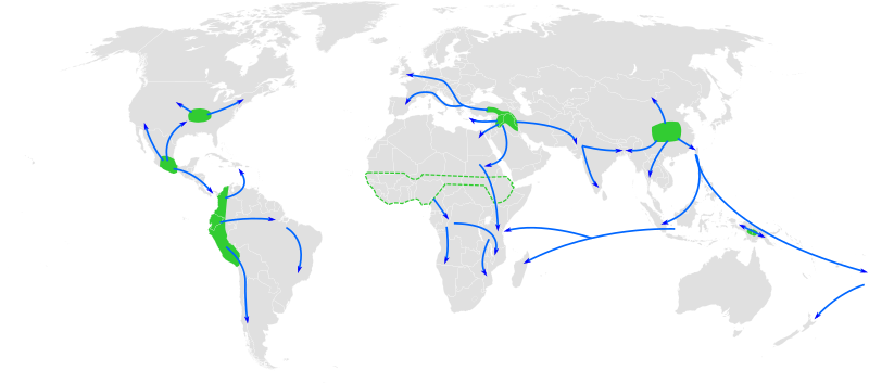
| 12:35, 29 Nyɔgevennebare 2010 |  | 940 × 415 (1.67 MB) | Joey Roe | {{Information |Description={{en|1=Map of the world showing approximate centres of agriculture and its spread in prehistory: eastern USA (4000-3000 BP), Central Mexico (5000-4000 BP), Northern South America (5000-4000 BP), sub-Saharan Africa (5000-4000 BP, |
Daga tontone
The following page uses this file:
Donɛɛ zaa daga tontone
Ana wikis mine ŋa maŋ tonna neŋ a daga ŋa:
- Era enna af.wikipedia.org
- Era enna ar.wikipedia.org
- Era enna ast.wikipedia.org
- Era enna as.wikipedia.org
- Era enna az.wikipedia.org
- Era enna bn.wikipedia.org
- Era enna ca.wikipedia.org
- Era enna de.wikipedia.org
- Era enna en.wikipedia.org
- Era enna en.wikiquote.org
- Era enna es.wikipedia.org
- Era enna es.wikibooks.org
- Era enna eu.wikipedia.org
- Era enna fa.wikipedia.org
- Era enna fi.wikipedia.org
- Era enna fr.wikipedia.org
- Era enna hy.wikipedia.org
Kaabu teŋdaa bonne kyaare a gaŋe ŋa.

